


Before treatment (left) and after treatment (right) images of the 1862 Will County Plat map
The maps were unearthed during a recent collections assesement. Lynne Smaczny, Executive Director of the Historical Society, comments that this inventory is long overdue. “We really don’t know of everything we have.” because her predecessors kept a more hands off attitude toward the counties archive collections. The maps having been left rolled and forgotten for so long were in serious stages of disrepair. Lynne, knowing the importance of these maps acted immediately to begin the process of restoration.
Having worked with Graphic Conservation in the past, on a project for the Des Planes History Center, Lynne contacted us directly to examine the maps and come up with a plan for restoration. While both maps suffered from severe surface dirt, desiccation and fragmentation, the first map was determined to be in better condition. However, it was also missing 4” of media area along the entire upper edge. The second map, although in much worse condition overall, contained the upper edge areas missing to the first. Conservation efforts have been targeted toward restoring and stabilizing the “home map” -the map in better condition while harvesting sections from the second “donor map” to be used to fill the losses of the first.
In order to stabilize the maps, many steps were necessary before they could be merged together. First, working with the home map and the sections of the donor map to be used as fills, the superficial surface dirt was reduced using various dry cleaning techniques. We then removed the varnish covering the surface of the maps using organic solvents.
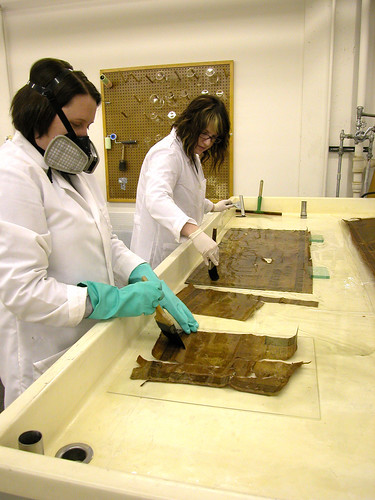
Conservators, Sharon Paschke (left) and Laura Moeller (right)
remove varnish from map fragments to be used as fills.
The brittle map had broken into hundreds of fragments, which were only being held together by a deteriorating linen backing. We gingerly removed the backing through a series of aqueous treatments, while keeping all the fragments together in a cohesive order. We replaced the old linen with modern archival Japanese tissue to stabilize the fragments.

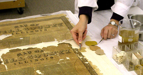
Conservator, Christina Marusich, uses a mylar template to
prepare fills from a large fragment from the second "donor"
map to be used as fills on the home map.
At this point, “The treatment became something similar to a jigsaw puzzle as we attempted to match up the sections from the two maps to form a cohesive whole” says head conservator, Christina Marusich. Using custom made mylar templates, the donor map fragments were painstakingly trimmed and hand placed to form a near seamless fit. The smaller loses which could not be filled with donor fragments, were filled using a matching liquid paper pulp. With the fills now in place, the map was placed in our oversize press to flatten.
Matching fiber colors for liquid paper pulp to be used in smaller fills.
Upon the maps removal from the press, a week later, a complete view of Will County circa 1862 can now be viewed and enjoyed. With this project, “We had the unique opportunity to use original media to fill losses which makes it even more exciting to see the piece come together as a whole” says conservator Sharon Paschke. “It is truly gratifying to know we are helping a community piece its past together with each part of the map we fill in.”
The discovery of this map could not have come at a more perfect time. The Will County Historical Society in years past has put much focus on its work preserving the history of I&M canal. The history of this historic landmark, once the main route connecting the Great Lakes to the Mississippi river, establishing Chicago as the transportation hub of the nation, has always overshadowed that of the origins of the county as a whole. The map has helped the Historical Society regain focus toward highlighting the history of the county as a whole starting with more inclusive programming for outlaying townships and has been the impetus for a new upcoming exhibit “Will County Origins”. The exhibit will display a comprehensive history on the pioneer settlement era of the county’s history, from the days of the Native Americans into the 1870’s. The restored 1862 map will act as the centerpiece and backbone for the exhibit, tying the individual township displays together.
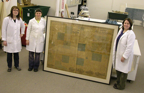
Conservators from left, Laura Moeller, Andrea Newberry and
Sharon Paschke with completed framed 1862 Will County Map.
To prepare the map for exhibit we had a deadline of the first week in February, which has given us only a few short weeks to complete the conservation. We knew the treatment would be time consuming and tricky not only due to the poor condition of the maps but because of the oversize nature of the items as well. We were definitely up to the challenge. Utilizing our full service lab and all members of our staff, we are specially equipped to handle oversize items even larger then this 4’ x 5’ wall map. When all said and done, we labored for over five weeks to prepare the map for its debut at the opening of “Will Count Origins”. The show opened February 15, and will run through May of 2009. You can view the 1862 Will County platt map at the Will County Historical Society in Lockport, IL.


1 comment:
Hey, thanks for pointing me to your blog. Nice work on the maps!
Post a Comment